Utah Terrain Base Map
Last update · Aug 2024
Category: Base maps Data Type: Imagery web service Steward: UGRC
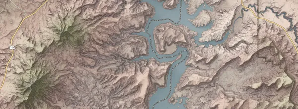
The Terrain base map highlights natural land forms and vegetation. It uses land cover polygons in conjunction with a digital elevation model (DEM) to display the different regions, elevation, and physiography of the state. A unique 2 layer hillshade and 50 foot contours highlight landforms and the shadows they cast. Other unique layers include water related land use agricultural areas and 2016 Great Salt Lake level.
Use the base map
From Discover
A closer look
This base map contains...
These raster tiles are pre-rendered at the common zoom scales , opens in a new tab . with a Web Mercator WGS84 projection (wkid/EPSG 3857).
Update history
- Aug 2024